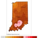
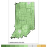
Meteorological spring started March 1st. Astronomical spring started March 20th. Baseball fans might consider the first day of spring to be Opening Day (March 29th this year). Regardless of when one defines the start of spring, so far it has been mostly on the cooler and wetter side. I have yet to meet anyone over the past few weeks who has expressed a general love for this weather with most asking when things are going to warm up. February and early March were noticeably warmer than average (Figure 1). This encouraged bulbs to coming up, trees to swell with buds, and increasingly more birds are singing their spring songs. But it has recently been gloomy and wet. Figure 2 shows how much cooler temperatures have been since March 8th of this year.
When can those patio cushions come out more permanently? When can neighborhood walks happen without worrying about a coat? Climate outlooks for the next 8-14 days (April 4-10) are favoring above-normal precipitation and temperatures. Keep those umbrellas nearby and flooding potential is likely to persist. The monthly (April) and seasonal (April-May-June) climate outlooks are indicating similar probabilities for warmer and wetter conditions.
The phases of the El Nino – Southern Oscillation (ENSO; e.g., La Nina) can be relatively useful indicators for Midwest winters. For example, a typical La Nina winter in Indiana is characterized by milder (i.e., warmer) and wetter conditions. Overall, that was the case this past winter. However, whatever phase the ENSO is in during the spring seems to do little more than confuse the climate models. Therefore, keep in mind that climate outlooks this time of year could be riddled with greater than usual uncertainty. It would certainly be nice if this upcoming planting season could be dry enough to provide enough field work days!
- Figure 1. Average temperature departure (degrees F) from the 1991-2020 climate normal period for February 1 through March 7, 2023.
- Figure 2. Average temperature departure (degrees F) from the 1991-2020 climate normal period for March 8-27, 2023.

