Summer just had to throw us a going away party in the form of extreme heat! Temperatures soared into the 90s during the final week of August, with heat index values over 100°F for much of the state. Lafayette, South Bend, and Fort Wayne all set daily records on Tuesday, August 27th for maximum temperatures at 96°F, 96°F, and 97°F, respectively. In South Bend, the heat index soared to 108°F, which was the highest this month. Heat index values were similarly high at the end of August 2023, but prior to that, they have not been that high in August since 1995.
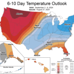
Those who desire cooler weather for outdoor activities and work will be happy to know the National Weather Service’s Climate Prediction Center (NWS CPC) is forecasting a likely chance of below normal temperatures for the entire Hoosier state for the first week of September (Figure 1). We could see lows below 50°F—sweater weather!
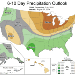
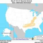
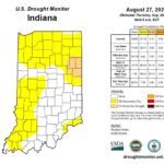
As for precipitation, it’s the same as last week—there’s just not much coming our way. The CPC predicts a very likely chance that precipitation will be below normal for most of the state to start September (Figure 2). It’s typical that we dry out this time of year, but there are still some areas with long term soil moisture deficits. This means that a pattern like this, even if only for a few weeks, could inhibit the development of flash drought. There are already indicators for rapid onset drought risk across central and southern Indiana come September (Figure 3), so be sure to have a plan as soils dry out these next few weeks. Abnormally dry conditions (D0) are already present across much of western and northern Indiana as of August 27, and moderate drought (D1) now covers a few counties in eastern Indiana (Figure 4).
- Figure 1: The National Weather Service’s Climate Prediction Center forecasts below normal temperatures for most of the eastern U.S., save Florida, for the first week of September.
- Figure 2: The CPC is predicting a very likely chance of below normal precipitation for Indiana for the first week of September.
- Figure 3: Rapid onset drought, also known as “flash drought”, will make a return to central and southern Indiana in the coming weeks as a much drier pattern takes hold.
- Figure 4: The U.S. Drought Monitor now displays abnormally dry conditions for over half the state, and moderate drought over several counties along the Ohio border.


