June Outlook Calling for Above-Normal Temperatures
Beth Hall
Indiana State Climate Office
The month of May was sprinkled with a record-breaking freeze over Mother’s Day weekend, followed by heavy rainfall the following weekend, with a roller coaster of cool periods and extremely warm periods. We often think of spring as being that transition between winter and summer with lots of ups and downs, but those extremes from one week to the next made it difficult to know what to expect more than a few days out. By the time the month ended, precipitation was slightly below normal in the southwestern and west-central parts of Indiana with the rest of the state slightly above normal. May’s temperatures averaged only 1°F to 2°F below normal. This is a great example of how averaging data can mask the extremes that made up reality!
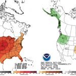
What will June be like? The latest national Climate Prediction Center outlooks for June are showing increased confidence for above normal temperatures and too much uncertainty for whether precipitation will be above or below normal (Figure 1). Over the next few weeks, temperatures are forecasted to be in the upper 80s to lower 90s with some intermittent rainfall due to convection. After that warm period passes, temperatures are predicted to return to more seasonal levels by mid-June.
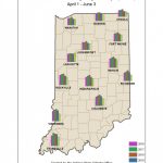
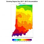
Modified growing degree day (MGDD) accumulations (since April 1) are still lagging behind previous years with the exception of Lafayette, IN area. The greatest lags are in the southern half of the state (Figure 2). Compared to what is climatologically normal, MGDDs are 120 – 60 units behind (Figure 3).
- Figure 1. Climate outlooks for temperature (left) and precipitation where the darker the shading indicates the greater the confidence that conditions will be above or below normal.
- Figure 2. Comparison of accumulated modified growing degree days since April 1 over the past several years.
- Figure 3. Accumulated modified growing degree days since April 1, 2020.


