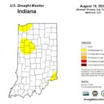
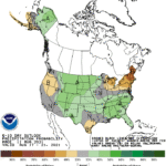
Well, it was a nice 4 weeks with no drought or abnormally dry designated areas across the state. Unfortunately, the lack of rain over the past few weeks have led to browning lawns, cracked soils, and other tell-tale signs that drought may be returning. The US Drought Monitor has designated three areas in Indiana as being Abnormally Dry (Figure 1). Looking at the national climate outlooks over the next few weeks is suggesting that spotty rain and dry conditions may persist, though there are slight indications that above-normal precipitation may be possible (Figure 2). Unfortunately, that confidence is low. This past week has been extraordinarily warm and muggy with temperatures in the 90s (Fahrenheit) and dew point temperatures in the upper 70s to lower 80s. Dew point temperature tend to stay relatively constant throughout the day and don’t vary as much as humidity. It is a truer measure of how much water vapor is in the air and indicates the temperature the air would need to cool down to in order for the air to be saturated and dew to form on surfaces. This is why glasses that have been in air-conditioned environments will fog up quickly when one goes outside in these conditions! When the dew point temperature is that high, there is little if any cooler relief over the nighttime hours. How rare are dew point temperatures this high? Over the past 10 years, dew point temperatures exceeding 75°F on 21 days at the Indianapolis Airport. Last year, there were only 3 days when this happened.
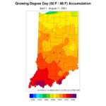
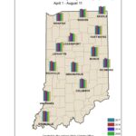
Modified growing degree days continue to accumulate, though accumulation caps the upper temperature threshold at 85°F. What this means is if the maximum temperature is over 85°, then the maximum temperature is replaced with the number 85 when deriving the daily average. For example, let us assume the minimum temperature was 68°F and the maximum temperature was 92°F, then a traditional growing degree day (base 50°F) would find the average temperature ((68+92)/2=80) and then subtract 50 (i.e., 80-50=30 growing degree-day units). However, some vegetation negatively responds to excessively warm temperatures, so modified growing degree days cap that upper limit at 85°F. In the example, therefore, the average temperature would be (68+85)/2=76.5 and the MGDD would be 76.5-50 = 26.5 MGDD units. Accumulated MGDD units range from 1900 in northern Indiana to over 2500 in southern Indiana (Figure 3). This is relatively comparable to recent years (Figure 4).
- Figure 1. US Drought Monitor for data through August 10, 2021.
- Figure 2. Precipitation outlook for August 17-21 indicating normal conditions likely throughout central Indiana with slight probabilities of above-normal precipitation in southern Indiana and below-normal precipitation in northeastern Indiana.
- Figure 3. Modified growing degree day accumulations from April 1 to July 28, 2021.
- Figure 4. Comparison of 2021 modified growing degree day accumulations from April 1 – August 4 to the past four years.


