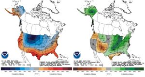
After the last several weeks of predominantly dry conditions, the national climate outlooks are finally showing confidence that temperatures should start shifting to cooler than normal and precipitation will be wetter than normal (see figure). Hurricane Laura will definitely help the precipitation side of that prediction with current tracks having the strongest rainfall amounts in the southern counties. Expect the rest of this week to stay on the warmer side, but by next week, temperatures should seem much more pleasant. From August 30th through September 7th (the period when the national Climate Prediction Center is showing confidence for these conditions), the normal amount of precipitation is between 1.25 and 1.50 inches. Average high temperatures are normally between 75°F (northern counties) and 85°F (southern counties). Therefore, keep these climatologically normal conditions in mind when interpreting the climate outlooks for below-normal temperatures and above-normal precipitation.
The probability of a La Niña developing has been increasing for the fall with moderate confidence it will continue through the winter. La Niñas can be a major driving factor for seasonal outlooks for various parts of the U.S., but not so much for the Midwest. Here, those correlations are weaker. This tends to confuse the various computer models that are run to predict the climate outlook for fall and winter in Indiana, leaving little-to-no guidance on temperature or precipitation for the next month (September) or 3-month period (September through November). Even the date of the first hard frost (i.e., minimum temperature at or below 28°F) does not seem to be impacted by the strength of a La Niña, El Niño, or Neutral phase.
