April Showers or Lingering Drought?
Beth Hall, Indiana State Climatologist
March wrapped up as one of Indiana’s wettest (44th wettest out of 126 years) and warmest (16th warmest). It was marked by unusually warm days and then cool days. Was it ever just average? Certainly, most days fell within the climatological range of temperatures. Precipitation seemed to be partial to the southern part of the state with only teasing amounts up north. This kept the northern counties in an Abnormally Dry or Moderate Drought status throughout the month while the southern counties were hoping to avoid any serious flooding.
Which brings us to April.
The national Climate Prediction Center is indicating enhanced probabilities for a warmer than average April, but unfortunately the predictive models were all over the place with respect to precipitation. As plants start to come out of dormancy and thoughts of early planting are crossing farmers’ minds, the question folks are wondering is if 2021 will be more like 2019 (wetter) or 2012 (drier). Shorter-termed outlooks are predicting enhanced probability for drier-than-normal conditions through the middle part of the month (April 12-20) and then after that, there is too much uncertainty. During this same period, temperatures are predicted to be favored toward cooler-than-normal conditions, so this should discourage evaporative demand from drying out soils too much. Additionally, the April-May-June outlook is still favoring wetter-than-normal conditions so the dry periods in April should not last long enough for us to start worrying at this point. With climate outlooks favoring warmer-than-normal temperatures over the next few months, a repeat of 2019 is highly unlikely. We’ll have to keep monitoring for potential drought development or enhancement.
The cooler-than-normal temperatures later this month could pose a risk for near freezing or freezing conditions, so keep an eye on those forecasts and don’t get too hasty to plant those flowers. In the meantime, sit back and enjoy the longer days and the nice evenings before Mother Nature starts testing our patience with the emergence of the Brood X cicadas, heat waves, and wind storms!
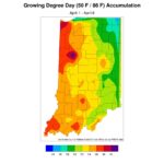
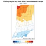
Finally, growing degree day accumulations have just started (Figure 1), but things are ahead of average in the northern half of the state and slightly behind average for this time of year along the Ohio River (Figure 2). Recent warm temperatures have helped get things started across the state, but look for these accumulations to slow down over the next few weeks.
- Figure 1. Growing degree day accumulations since April 1, 2021
- Figure 2. The growing degree day departure from average from April 1 through April 6

