5/9/2019
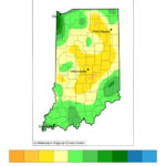
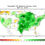
The biggest topic seems to be how wet it is and how much more rain Indiana can expect. So far, May has experienced near-normal precipitation throughout the central part of the state with 0.5”-2” in southern and northern regions (Figure 1). Combining this with April’s precipitation, however, means the soil moisture is still 60mm to over 80mm above average (Figure 2), causing saturated soils and the propensity for flooding anytime precipitation occurs. Speaking of which, 0.25”-1.5” of additional precipitation is expected over the next 7 days with the lower amounts favoring the northwestern part of the state. Could there be drying beyond that? The climate outlook for May 16-22 is indicating slight probabilities for below-normal precipitation in the northern counties, but the rest of the state is statistically uncertain to predict above- or below-normal precipitation with confidence. However, keep in mind that normal precipitation (based upon 1981-2010 data) during that time period is still 1”-1.5”.
Modified growing degree-days (MGDDs) since April 1 have accumulated to 150-400 (from north to south) across the state, which is within 40 units of the climatological average. Northern Indiana is most behind in MGDDs with a departure of -40 to -60 units. The climate outlook for May has significant probabilities of above normal temperatures so hopefully on days when it is not raining, skies will clear enough to allow more rapid MGDD accumulation.
- Calculated Soil Moisture
Beth Hall, PhD
Director, Indiana State Climate Office

