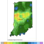
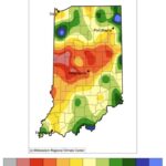
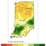
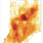
Rain continues to be spotty across Indiana with some areas getting the lion’s share while others are barely seeing a drop. When considering a recent 7-day period (June 1-7, 2022; Figure 1), central Indiana seemed to have missed out on most of the rain. This translated to central Indiana receiving around 5%-25% of what it normally received during that same period from 1991-2020 (Figure 2). However, if one considers the recent 30-day period (May 9 – June 7, 2022), the whole northern half of Indiana appears to have only received 25%-75% of what has normally fallen (Figure 3). The period of consideration when looking at recent climate is important, and no time frame is necessarily superior to another. It all depends upon the application. For example, being on the dry side over a 7-day period in May could be preferable for agriculture so planting can happen with fewer muddier fields. However, a 30-day dry period could impact deeper soil moisture levels, groundwater supplies, and stream levels.
Abnormally dry conditions were briefly introduced in northwest Indiana last week. However, rain events earlier this week provided 1”-2” of new precipitation to this area, lifting that classification … for now. Climate outlooks for the 8-14-day period is slightly favoring below-normal precipitation across Indiana and increased chances of above-normal temperatures. Soils could dry out quickly under these conditions causing stress to shallow-root vegetation.
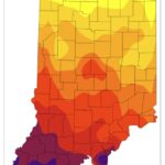
Accumulated modified growing degree units are quickly increasing with these warmer temperatures (Figure 4). When considering an accumulation start date of Aril 15th, the southern two-thirds of Indiana is anywhere from 20 to 80 units ahead of the 1991-2020 climatology (Figure 5).
- Figure 1. Accumulated precipitation from June 1-7, 2022.
- Figure 2. Precipitation for June 1-7, 2022 represented as the percentage of what normally fell during that period from 1991-2020.
- Figure 3. Precipitation for May 9, 2022 through June 7, 2022 represented as the percentage of what normally fell during that period from 1991-2020.
- Figure 4. Modified growing degree day (50°F / 86°F) accumulation from April 15-June 7, 2022.
- Figure 5. Modified growing degree day (50°F / 86°F) accumulation from April 15-June 7, 2022, represented as the departure from the 1991-2020 climatological average.
