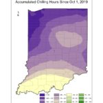
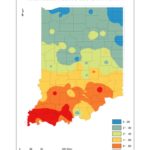
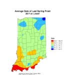
Over the past 30 days, southern Indiana has received above-average precipitation which has caused some flooding and well-saturated fields. Northern Indiana has received near-normal precipitation, yet there are localized areas of pooled water. Snowfall across the state has been below normal throughout the entire season, mostly due to temperatures staying above freezing. As the dormant season is wrapping up, accumulated chilling hours (35°F-45°F) are well ahead of normal (Figure 1), which is hopefully a good sign for perennials! Growing degree days (base 50°F) have started to accumulate (Figure 2), which will also encourage plants to start emerging and leafing out. Unfortunately, Indiana is statistically likely to still experience at least one more hard frost. The average date of the last frost with temperatures 28°F or lower is between April 3-10 across most of the state (Figure 3).
Climate outlooks over the next few weeks are showing increased confidence of above-normal temperatures and below-normal precipitation. This will hopefully help dry things out enough to be able to start preparing for this upcoming growing season! Unfortunately, the climate outlook for April is suggesting increased confidence of above-normal precipitation for the southern half of Indiana, but at this time those amounts do not appear to be as high as they were in 2019.
- Figure 1. Accumulated chilling hour (35°F-45°F) departures for 2019 October 1 through 2020 March 24 compared to the 1986/1987 – 2015/2016 base period.
- Figure 2. Accumulated modified growing degree days (base 50°F) since 2020 March 1.
- Figure 3. Average date of the last frost with temperatures at or below 28°F.


