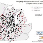
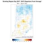
A break from the heat has commenced as average temperatures dropped to 2-6◦F below normal this week. From May 8-14, average temperatures ran from 5◦F above normal in the southeast to 13◦F above normal in the northwest. Across the entire Midwest, there were 858 maximum and 659 minimum high temperature records broken or tied (Figure 1). The third week of May also trended warmer with southeastern Indiana 6-7◦F above normal and departures 2-3◦F above normal in northwestern Indiana. These warmer temperatures enhanced vegetation growth, allowed row-crop agriculture to resume planting, and gave modified growing degree day (MGDD) departures to catch up to near normal for most in the state (Figure 2). In fact, central and south-central Indiana is now showing above normal MGDDs.
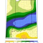
The northern part of the state received normal precipitation from May 15-22, with heavier amounts falling in southern Indiana. Heavy rains associated with thunderstorms accounted for 175300 percent of normal precipitation for this section of the state (Figure 3). Ten stations in southern Indiana reported that daily precipitation records were broken or tied from May 15-21. Franklin County recorded 5.13 inches of rain, which was 4.07 inches above normal for the week. Their largest single day maximum precipitation (2.80 inches) occurred on May 15. In contrast, there has been some concern with drying along the Indiana/Kentucky border, but not enough to introduce abnormally dry (D0) into the US Drought Monitor. On May 21, there were three confirmed tornadoes that occurred in Brown County (EF-0), Johnson County (EF-0), and Shelby County (EF-1). Fortunately, there were no injuries or deaths reported, but the region did experience damage to building structures and trees. Heavy rains slowed progress of planting across the state. Furthermore, wind continued to present challenges as many stations across Indiana reported wind gusts in excess of 30 mph on May 20.
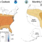
After widespread opportunities to receive 0.75-1.5 inches of precipitation through May 28, weather models call for a decrease in precipitation, providing an opportunity to finish the 2022 planting season. The 6-10 day outlook (May 30-June 3) and 8-14 day outlook (June 1-7) both call for enhanced confidence in above normal temperatures and below normal precipitation. The Climate Prediction Center June Outlook (Figure 4) also calls for higher confidence in above normal temperatures and equal chances in above or below normal precipitation.
- Figure 1. Midwestern daily high temperature records broken or tied from May 8 – 14.
- Figure 2. MGDD accumulation from April 1 – May 23, 2022, represented as the departure from the 1991-2020 climatological average.
- Figure 3. Accumulated precipitation from May 15-22, 2022, represented as a percentage of the 1991-2020 climatological average.
- Figure 4. Climate Prediction Center June 2022 temperature and precipitation outlooks.


