Happy Independence Day from the Indiana State Climate Office!
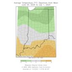
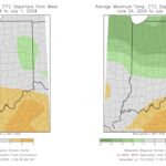
Temperatures were much more pleasant over the past seven days (June 24-July 1) compared to the heat experienced in mid-late June. Across Indiana, temperatures varied from below to above normal from north to south (Figure 1). Southern Indiana had locations with temperatures up to 1°F above normal, while south-central Indiana observed near-normal temperatures. Areas north of Indianapolis had locations averaging 2-3°F below normal. Minimum temperatures were largely normal for the week (Figure 2, left), whereas maximum temperatures were well below normal for some (Figure 2, right). The largest maximum temperature anomalies occurred in the northern third of the state, with temperatures 3-4°F below normal.
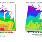
Growing degree days (GDDs) since April 1st remain above normal for Indiana (Figure 3). Northwestern Indiana is 100-150 GDDs above normal as of July 1, while the rest of the state is 150-200 units above normal.
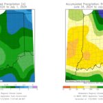
Precipitation was sparse for many across the state this past week but heavy for some (Figure 4, left). Southern and western portions of the state received below-normal precipitation, less than 75 percent of normal (Figure 4, right). One area south of Terre Haute received less than 50 percent of normal rainfall. Williams 3 SW, located in Martin County, had no measurable rainfall this week, earning the title of the driest station in the state. Northeastern portions of the state received above-normal rainfall, with extreme northeast Indiana receiving almost double their normal rainfall. Rochester 2.4 NW, located in Fulton County, recorded 3.14 inches of rain for the week, the highest total in the state.
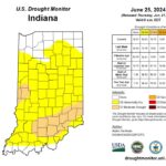
Drought has increased as of late, particularly in southern Indiana (Figure 5). The recent lack of rainfall in southern portions of the state has resulted in moderate drought (D1) developing in southeast and west-central Indiana. There was no moderate drought anywhere in the state last week, indicating worsening conditions, especially in southern Indiana. Most other counties in the state, with the exception of the northern and southern fringe counties, are experiencing abnormally dry (D0) conditions.
Looking ahead, conditions look to heat back up. Temperatures are expected to be above normal over the next 7 days, particularly in southern Indiana. Precipitation forecasts hint at slightly above-normal rainfall–a welcomed relief for many.
- Figure 1. Average temperatures for June 24-July 1, 2024 represented as the departure from the 1991-2020 climatological average.
- Figure 2. Left – Average minimum temperatures for June 24-July 1, 2024 represented as the departure from the 1991-2020 climatological average. Right – Average maximum temperatures for June 24-July 1, 2024 represented as the departure from the 1991-2020 climatological average.
- Figure 4. Left – Accumulated precipitation for June 24-July 1. Right – Accumulated precipitation for June 24-July 1 represented as the percent of the 1991-2020 climatological average.
- Figure 5. June 25 US Drought Monitor map.
