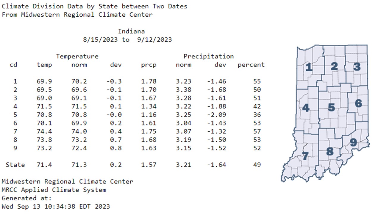
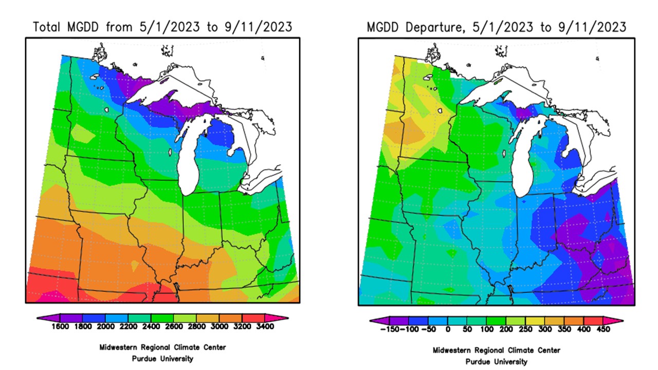
The fall crisp was in the air this morning (9/13), so cool that I had to grab that sweatshirt I bought in mid-August while getting my kiddo on the bus. It was actually refreshing, in a sense. Minimum temperatures in Crawfordsville (Montgomery County) and Rensselaer (Jasper County) dropped to 44F this morning, which were the coolest in the state. Family traveling in northern Minnesota called this morning to report a low temperature of 28F. That is just downright cold, and they can keep that up north for the time being. Over the last 30 days (8/15-9/12) though, temperatures have been normal (Figure 1). This is misleading, however, especially as we have experienced oppressively hot and milder temperatures over the past 30 days. Since May 1, modified growing degree days (MGDDs) have accumulated between 2200 and 3200 MGDDs (Figure 2, left), which was near normal to 150 units below normal across the state (Figure 2, right).
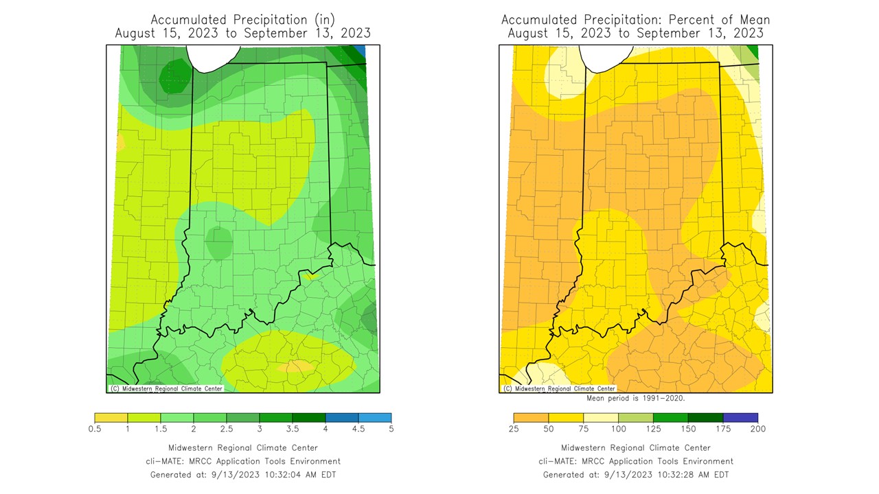
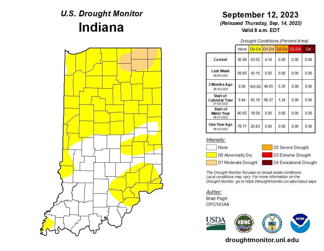
The bigger story continues to be the dry conditions that are creeping back into the state. This is not at all surprising as nearly the entire state saw less than 75 percent of normal precipitation over the last 30 days (Figure 3). Central Indiana measured between 1 and 1.5 inches of rain since August 15, which was between 25 and 50 percent of normal. Vegetation is dormant in most locations, agricultural crops are rapidly maturing, and water levels have dropped dramatically as a result. The release of the September 12 US Drought Monitor depicts 63.52% of the state in at least abnormally dry conditions with 4.14% in Moderate Drought (Figure 4).
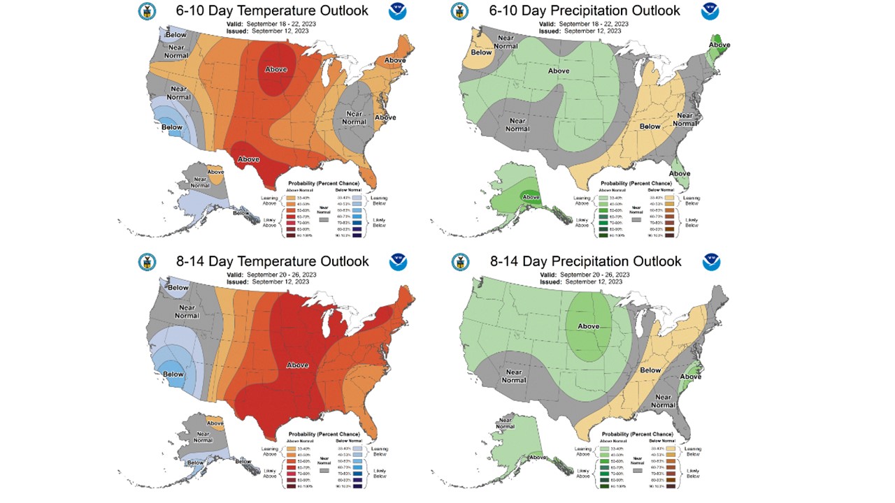
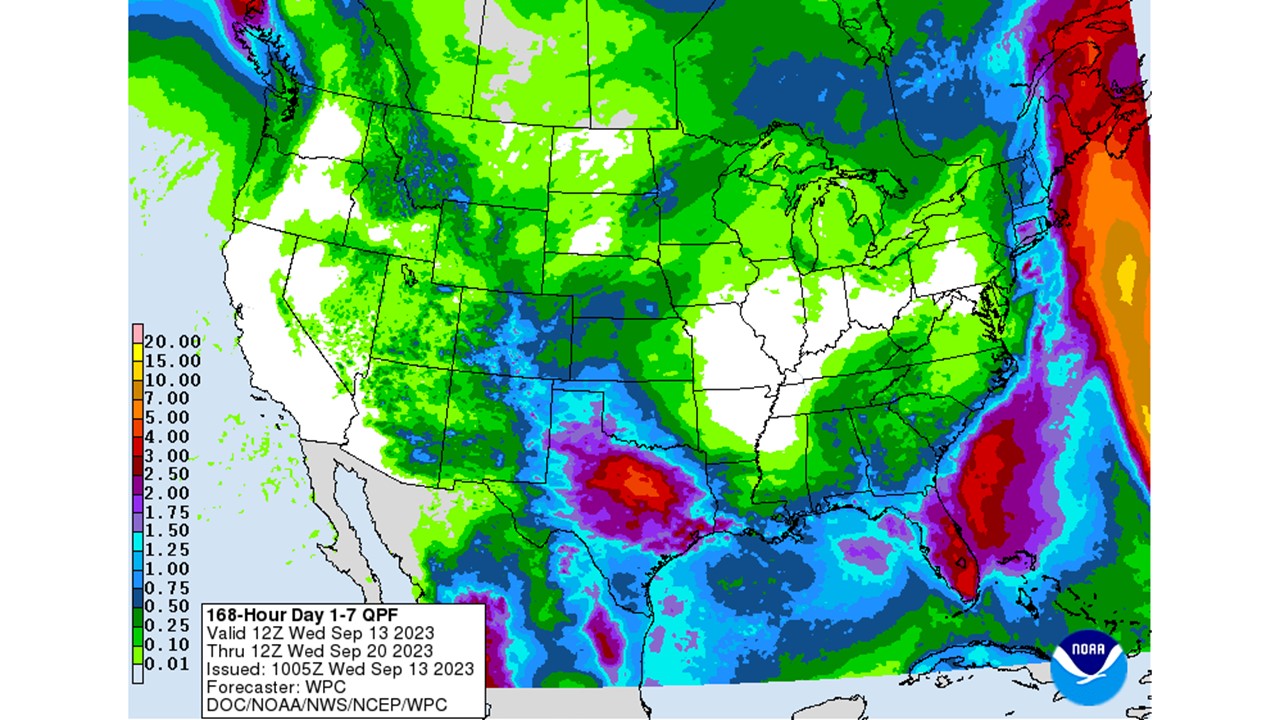
The national Climate Prediction Center (CPC) still expects drought to linger and expand in Indiana throughout the fall. People are asking about the expected El Niño and continued drought through the winter already. We’ve got a bit of time before we can truly answer that question, especially as there is a lot of uncertainty with the outlook for this fall (September, October, and November). That being said, the forecast is not conducive for rain through September 20 (Figure 5). Areas north of I-70 could see less than a tenth of an inch, which will not help ongoing drought concerns. The reprieve in warm temperatures has certainly helped with moisture loss, but they are not expected to last as a warmup is on the way. The CPC has increased confidence in above-normal temperatures through the end of September (Figure 6). Coupled with this are elevated chances for below-normal precipitation for much of the state. The good news: harvest conditions should be great (typing this as I knock on wood).
-
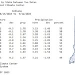
- Figure 1: Climate Division data by state, between August 15 and September 12, 2023, which includes observed temperature and precipitation, normal temperature and precipitation, temperature deviation from normal and percent of normal precipitation.
-
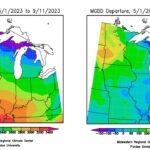
- Figure 2: Total Accumulated Midwest Modified Growing Degree Days (MGDDs) May 1-September 11, 2023 (left) and Total Accumulated MGDDs represented as the departure from the 1991-2020 climatological normal (right).
-
- Figure 3: Observed precipitation (left) and percent of mean precipitation (right) for August 15-September 13, 2023.
-
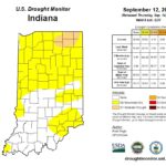
- Figure 4: September 12, 2023, US Drought Monitor. The US Drought Monitor is released every Thursday morning by 8:30 AM.
-
- Figure 5: NWS Weather Prediction Center 7-day quantitative precipitation forecast for the continental United States, valid September 13-20, 2023.
-
- Figure 6: CPC 6-10 day temperature and precipitation outlooks for the United States, valid September 18-22, 2023 (top). CPC 8-14 day temperature and precipitation outlooks for the United States, valid September 20-26 (bottom).