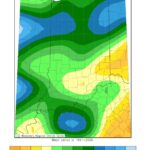
Abundant rainfall has eliminated any drought across the Hoosier State, and we have April showers to thank for that. Fort Wayne had its wettest April on record with a whopping 7.39 inches of precipitation, over 3 inches above the normal 3.74 inches for April. In Indianapolis, it was the 8th wettest April on record with 7.77 inches, and in Frankfort, it was the 2nd wettest with 7.99 inches. 30-day precipitation departures reveal above normal precipitation for just about the entire state (Figure 1).
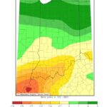
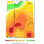
90-day precipitation departures tell a different story, with parts of southern Indiana up to 3 inches below normal (Figure 2). Even more significant are the 1-year departures, with most of the state anywhere from 4 to 12 inches below normal (Figure 3). Indiana will continue to need consistent precipitation to maintain the short-term recovery seen so far this Spring. The National Weather Service’s Climate Prediction Center (CPC) has forecasted near normal precipitation for most of the state for May 15-21, leaning above normal for southern Indiana. Through May 31, the outlook is for above normal precipitation for solely southern Indiana and near normal elsewhere. In total, the Weather Prediction Center (WPC) expects 0.5-1 inch of rain for most of Indiana through May 16.
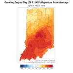
In the agricultural growth department, Indiana is above normal. Much of central and southern Indiana are now well above normal when it comes to Modified Growing Degree Data accumulations (Figure 4). Since more precipitation is expected—and above normal temperatures are expected through at least May 17, according to the CPC—expect MGDD accumulations to climb more in the coming weeks.
- Figure 1- 30-day Precip. Departures for Indiana
- Figure 2 Average Minimum Temp Departure from Mean April 22, 2024 to April 30, 2024
- Figure 3-1 year precip totals
- Figure 4- GDD ABOVE NORMAL APRIL 15-MAY7


