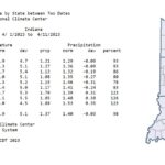
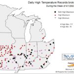
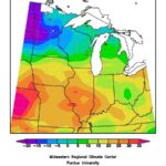
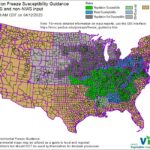
Much like March, April has gotten off to a warm start. Through the first eleven days, the state average temperature was 5.1◦F above the 1991-2020 climatological normal (Figure 1). High temperatures ranged from 60-70◦F, which was anywhere from 3-7◦F above normal. Low temperatures were not as anomalous, but slightly above normal for most of the state. As a result, over a dozen Indiana stations either had daily high maximum and/or minimum temperature records broken or tied (Figure 2). Modified Growing Degree Days (MGDDs), derived by temperatures beginning April 1, were above normal for most of the state. Highest deviations occurred in central and southern Indiana (Figure 3). Warmer temperatures have allowed vegetation to break dormancy up to central Indiana. As a result, horticultural plants became susceptible to frost and freeze damage should there be another cold snap (Figure 4).
Rainfall averaged 1.37 inches across the state (April 1-11), with highest amounts falling in southern Indiana (Figure 1). All of the rain was measured in the first week and occurred nearly a week ago. Dry weather and abundant sun allowed soils to begin drying and warming. On April 12, Purdue Mesonet 4” soil temperatures were in the low to mid-50s statewide (Figure 5). Field work (anhydrous applications, spraying, and yes…even some planting) has begun for some producers given the recent pattern shift.
The dry trend should remain for the next week, which will allow for continued field work. The Climate Prediction Center expects near- to above-normal temperatures through the end of the month. Precipitation is expected to continue below normal through April 21 and then shifting to near normal toward the end of the month.
- Figure 1: Indiana climate division and state temperature, normal temperature, temperature departure from normal, precipitation, normal precipitation, precipitation departure from normal, and percent of mean precipitation for April 1-11, 2023.
- Figure 2: Midwest daily high temperature records broken or tied during the week of April 1-7, 2023.
- Figure 3: Accumulated Midwest Modified Growing Degree Days (MGDDs) (April 1-10, 2023) represented as the departure from the 1991-2020 climatological normal.
- Figure 4: Vegetation Impact Program’s Vegetation Freeze Guidance shows the locations with susceptibility to frost and or freeze damage. The map above depicts guidance submitted through April 12, 2023.
- Figure 5: Purdue Mesonet 4” soil temperature across the state. Data may be obtained through the Purdue Mesonet Data Hub.
