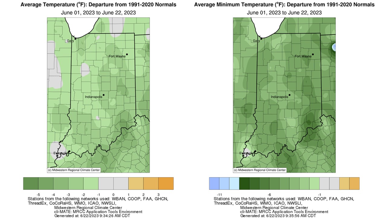
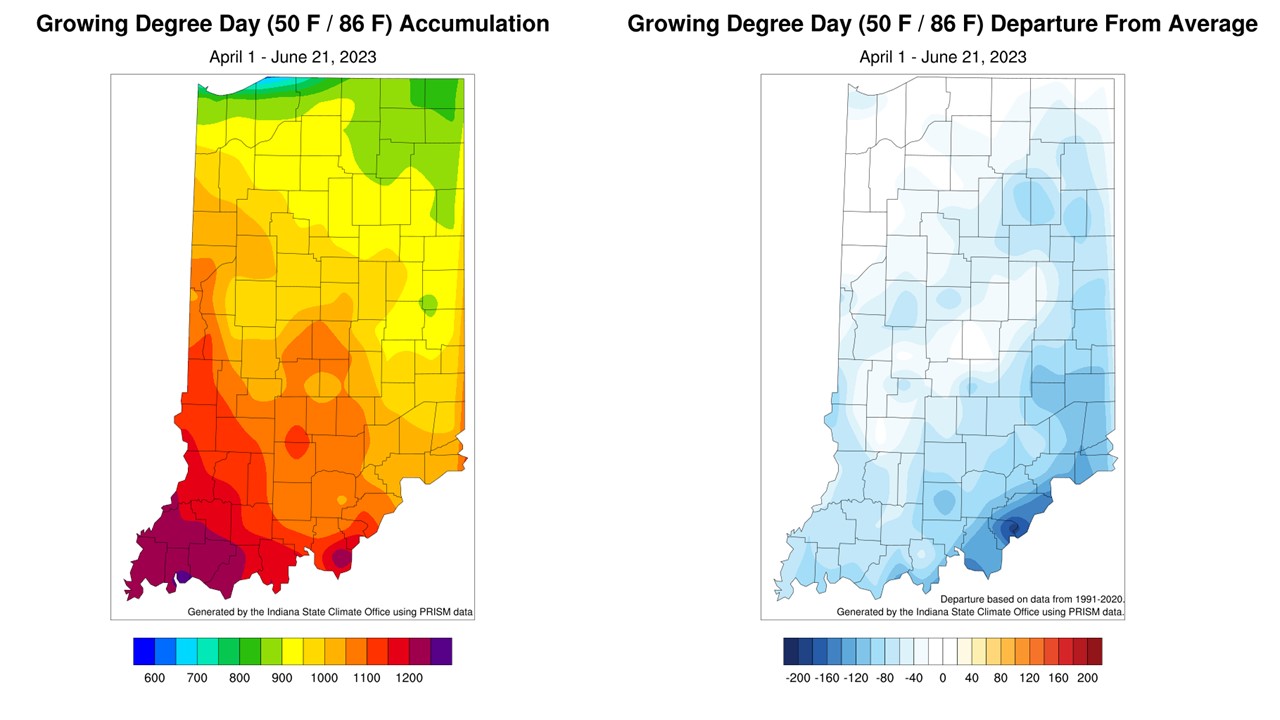
Below-normal temperatures continued through the first 21 days of June as the state average temperature was 68.3°F, which was 1.8°F below the 1991-2020 climatological normal. Temperature departures were 1-5°F below normal across the state, with larger departures in eastern and southern Indiana (Figure 1, Left). Maximum temperatures were near normal for the entire state, and minimum temperatures ran 1-9°F below normal (Figure 1, Right). Dry air and limited overnight cloud cover are to blame. Several locations measured minimum temperatures in the 40s at some point this month, but Franklin County recorded a chilly 36°F on June 9th. This station also tied with Shelby County for the second highest temperature recorded so far this month, 95°F, which occurred on June 3. Dubois County hit 97°F on June 4th. There were more than 20 daily low temperature records broken or tied during the second week of June. Over the last week, maximum temperatures ran 1-3°F above normal stretching from west central to northeast Indiana, and 1-6°F below normal to the southern and eastern portions of the state. Modified Growing Degree Days (MGDDs) have accumulated between 600 and 1300 units in the state (Figure 2, Left), which is near normal to over 120 units below normal (southeastern Indiana).
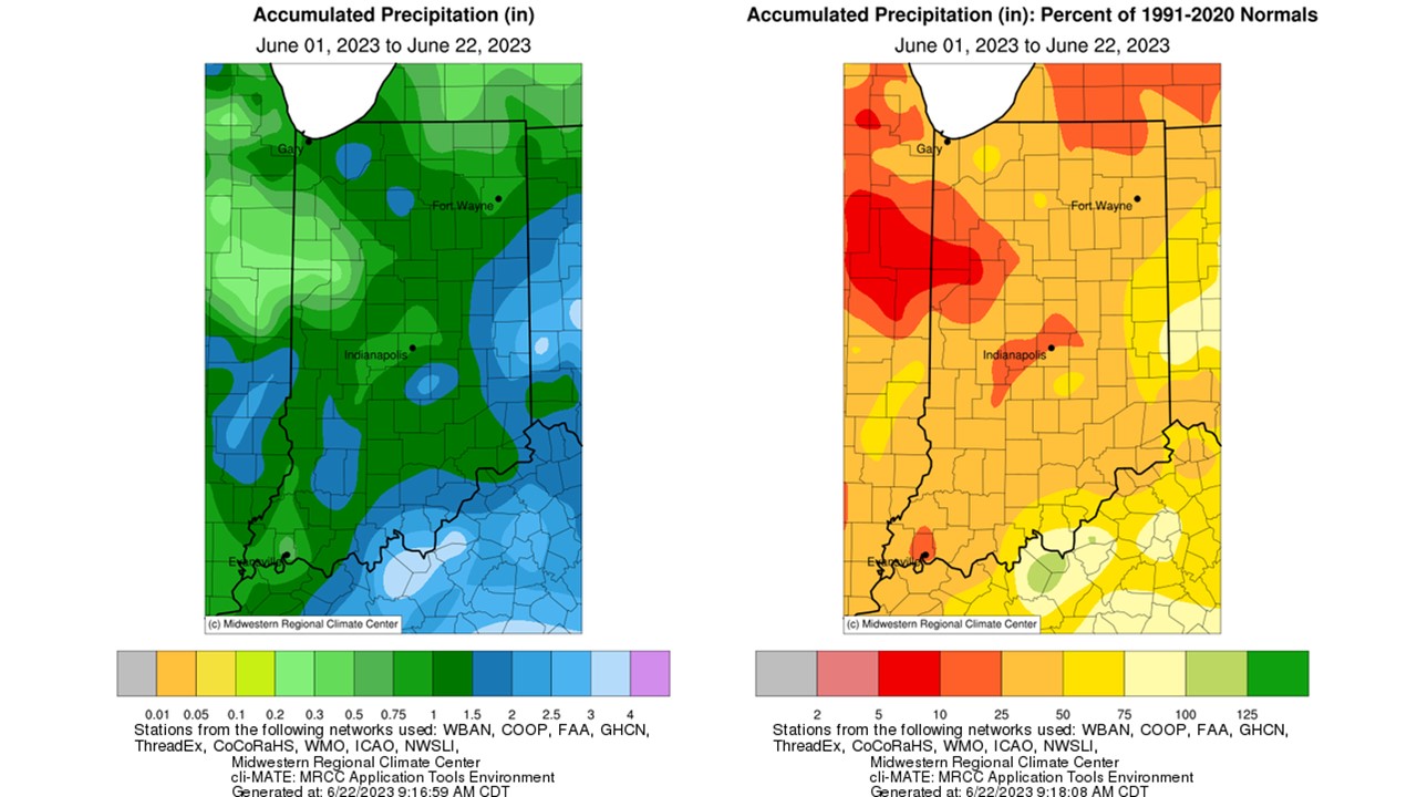
Last week, the state had some relief as the rain returned for most. The state average precipitation (June 1-21) was 1.33 inches, which was 1.63 inches below normal or 45 percent of normal. The heaviest precipitation fell in eastern and southern Indiana, where more than 1 inch fell in spots (Figure 3, Left). Still, all locations received below-normal precipitation. West-central and other isolated areas received less than 25 percent of normal precipitation (Figure 3, Right). Warren, Benton, and Tippecanoe Counties were the driest, receiving less than 10 percent of normal precipitation for the period. Johnson County had the highest precipitation total in the state, 2.90 inches (June 1-21), most of which (1.95 inches) was measured on June 12.
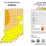
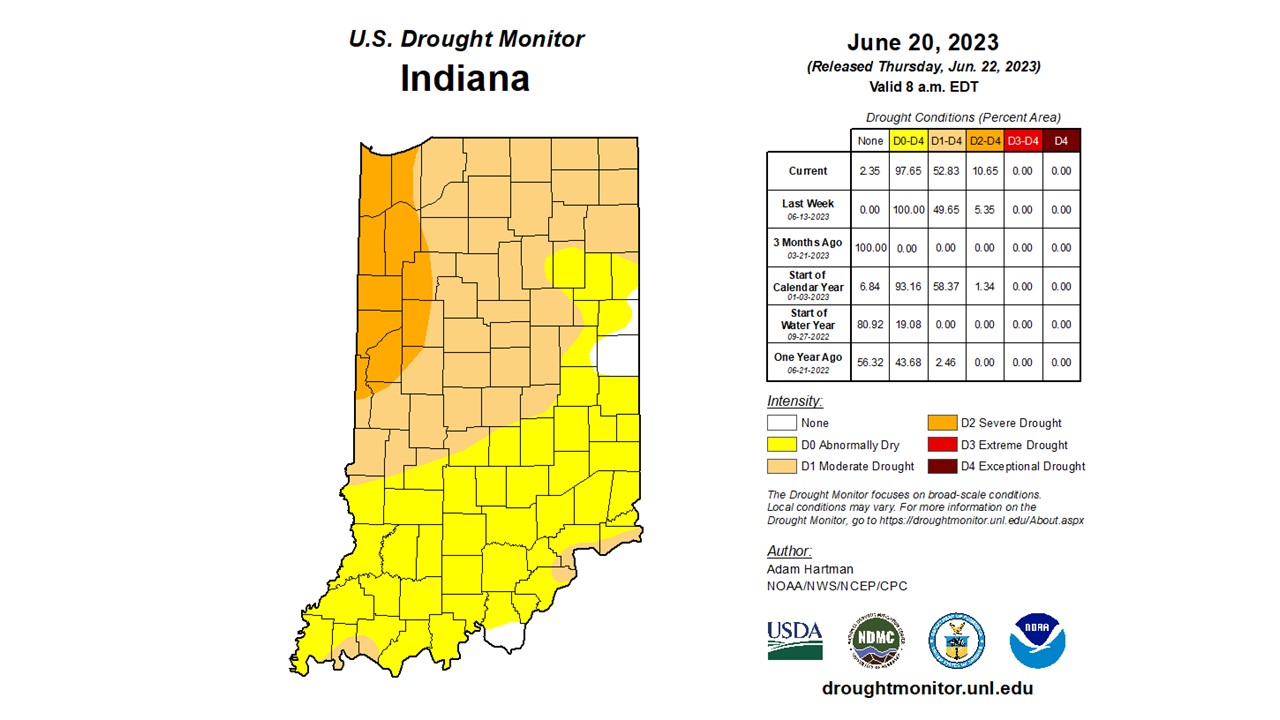
The June 20 US Drought Monitor brought expansions of Severe Drought (D2) and Moderate Drought (D1) categories in the state and some improvement in the east (Figure 4). Over 10 percent of the state is in D2, which doubled in size from the previous week. Eastern Indiana saw a 1-category improvement due to the rain last week and even introduced no drought in portions of Adams, Jay, Randolph, and Delaware Counties. Southern Harrison County also improved to no drought this week. Overall, conditions continue to worsen as most locations have burned through the moisture that arrived last week. Yards are dormant, crops are stressed, water levels are low, and producers are concerned about hay production, and burn bans have been enforced in Newton, Jasper, Benton, Warren, Fountain, and Vermillion Counties. Keep in mind, the ongoing drought is a regionwide issue. Over 92 percent of the Midwest is at least Abnormally Dry (D0) or in some level of drought. Unfortunately, the pattern is not expected to change much.
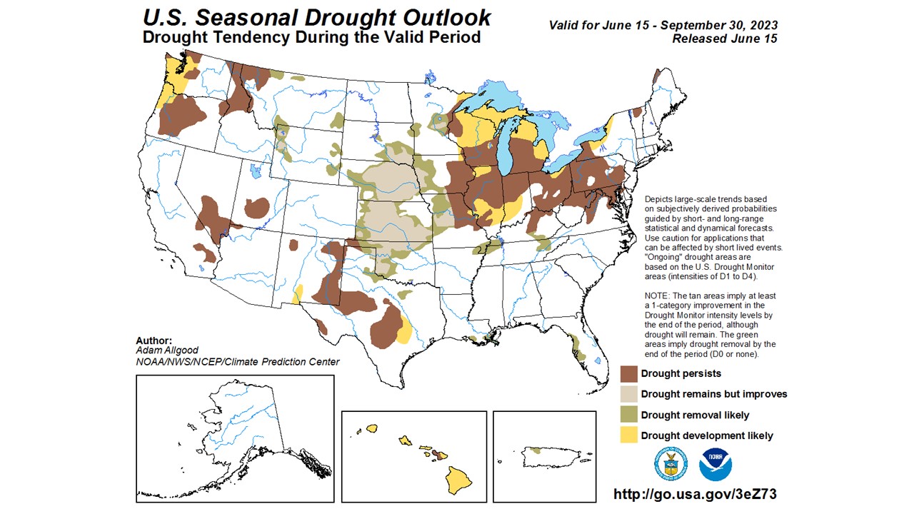
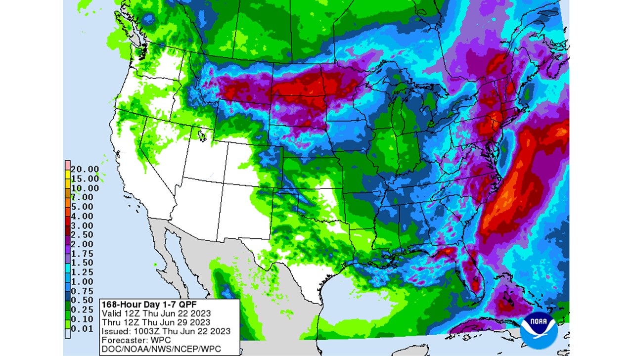
The precipitation forecast through June 29 calls for less than 0.75 inches for the entire state (Figure 5). Notice that forecast precipitation amounts are less than 0.25 inches for areas in D2 and D1 drought categories. The Climate Prediction Center has elevated confidence in continued below-normal to near-normal temperatures and near-normal precipitation through July 5th. The US Seasonal Drought Outlook, released on June 15, expects persistence and development of drought in the state through September (Figure 6). Drought conditions will likely worsen before it gets better.
-
- Figure 1: Average temperature (left) and Average Minimum Temperature (right) for June 1-22 represented as the departure from the 1991-2020 climatological normal.
-
- Figure 2: Total Accumulated Indiana Modified Growing Degree Days (MGDDs) April 1-June 21, 2023 (left) and Total Accumulated MGDDs represented as the departure from the 1991-2020 climatological normal (right).
-
- Figure 3: Interpolated map displaying accumulated precipitation for June 1-22, 2023 (left). Interpolated map displaying accumulated precipitation as a percent of the 1991-2020 climatological normal (right).
-
- Figure 4: June 20, 2023, US Drought Monitor. The US Drought Monitor is released every Thursday morning by 8:30 AM.
-
- Figure 5: NWS Weather Prediction Center 7-day quantitative precipitation forecast for the continental United States, valid June 22-29, 2023.
-
- Figure 6: US Seasonal Drought Outlook valid for June 15-September 30, 2023, which is available via the Climate Prediction Center.