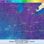
The earth’s position and movement around the sun welcomed the spring equinox on March 19th, and meteorologists in the northern hemisphere welcomed spring on March 1st. Unfortunately, the atmosphere – particularly over the midwestern and Great Lakes states – refused to acknowledge those dates to offer us a more traditional spring. Sure, Indiana’s spring 2020 has been drier than 2019. The compromise to that gift, however, came with periods of below normal temperatures, and potentially below freezing, damaging conditions this Friday across much of state (Figure 1). This may not even be a one-and-done phenomenon as the National Weather Service is predicting a risk of much below-normal temperatures for the far northern counties in Indiana for May 13-15. Is Mother Nature aspiring to break low temperature records? The record latest dates for 32°F or lower minimum temperatures are mostly after May 15th, so we will just have to watch and see.
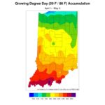
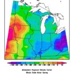
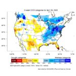
In addition to being unwelcomely cold, these below-normal temperatures have had two other effects. First, growing degree days are accumulating at a slower rate. Currently, Indiana is about 50-80 units below normal modified growing degree-day accumulations (Figures 2 and 3). This has slowed a lot of plant growth and also kept soil temperatures cooler. The other effect is the reduction to evapotranspiration rates (Figure 4). April was drier than normal and May has not yet started to compensate for that. Looking at precipitation alone might lead one to assume agricultural drought is developing. However, cooler temperatures are helping to keep that moisture in the ground longer than what would otherwise be normal given the decreased precipitation.
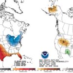
The climate outlook for May is predicting below-normal temperatures. The precipitation outlook is split across the state where the models are showing weak confidence for below-normal precipitation in the northern half of the state and too much uncertainty for the southern half (Figure 5).
- Figure 1. Forecasted minimum temperatures for early morning Saturday, May 9, 2020
- Figure 2. Modified growing degree-day accumulation for April 1 – May 5, 2020
- Figure 3. Modified growing degree-day departure from normal for the accumulations between April 1 – May 5, 2020
- Figure 4. Two-week Evaporative Drought Demand Index (https://psl.noaa.gov/eddi/) representing April 17 – April 30, 2020
- Figure 5. Climate outlooks for May 2020 that indicate the level of confidence for above- or below-normal conditions. Temperature outlook is on the left; precipitation outlook is on the right
