There is some very exciting news this week for Indiana with respect to the U.S. Drought Monitor. For the first time since April 25, 2023, the entire state is void of any Abnormally Dry (D0) or Drought (D1-D4) conditions. I would include the map but … drumroll, please … there’s nothing to show! This is incredible! Soil moistures are near or above normal; streamflow is mostly near or above normal, and groundwater levels are indicating a rising trend. Certainly, flood warnings are still occurring and there are some areas that could use a break from all this rain. However, this is an ideal time of year to try and replenish all moisture deficits Indiana can, since this is the rainier time of year and soon temperatures will increase causing rates of evapotranspiration to climb.
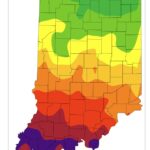
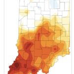
Modified growing degree day (MGDD) accumulations have slowed a bit in northern Indiana but are greater than normal for the southern half of the state (Figures 1 and 2). While recent conditions have felt cooler, climate outlooks for the next two weeks are strongly favoring above-normal temperatures. This will likely cause a rapid increase in MGDDs as well as soil temperatures. Precipitation outlooks are slightly favoring below-normal amounts for the May 1-5, with more near-normal conditions through May 8th.
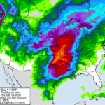
The 7-day precipitation forecast is highlighting a very strong precipitation event to the west of Indiana (Figure 3) mostly occurring over this coming weekend and into early next week. Forecast models have stayed relatively consistent with this location, but certainly keep an eye on the forecasts in case this system decides to shift slightly to the east.
- Figure 1. Modified growing degree day (50°F / 86°F) accumulation from April 1-25, 2024.
- Figure 2. Modified growing degree day (50°F / 86°F) accumulation from April 1-August 25, 2024, represented as the departure from the 1991-2020 climatological average.
- Figure 3. Seven-day total precipitation forecasted for the period from April 26 through May 3, 2024.


