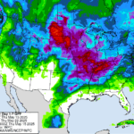
After the brutal heatwave hit us as June transitioned to July, any future above-normal temperatures may seem normal for this time of year. The national Climate Prediction Center is indeed favoring more above-normal temperatures throughout the middle of July, so hopefully you have started acclimating to Indiana summers! The key is to hope humidity stays…Read more about Warm temperatures and more rain on the way[Read More]
Beth Hall

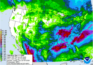
Since last Friday, many parts of Indiana have seen a significant amount of rain (Figure 1). However, the spatial variability illustrates how there can never be enough ground observations and measurements to tell the entire story. In a 24-hour period over the weekend, an observer in Lafayette, Indiana recorded 3.58” and yet 3 miles to…Read more about Are cooler, drier conditions in our future?[Read More]
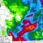
Indiana saw a lot of precipitation the early part of this past week with rainfall totals ranging from 0.5” or greater in the northern and far southwestern counties to over 5” in south-central Indiana. In fact, an observer just south of Bedford, IN reported a combined total of 5.80”! Figure 1 shows the 2-day total…Read more about An impressive amount of rain[Read More]
Indiana has exceeded its previous maximum duration record of 46 weeks in drought (since May 20, 2025) since the U.S. Drought Monitor (USDM) began in 2000. The previous record was 44 consecutive weeks. This was a bit of a surprise when I saw this, since this includes the drought of 2012 and multiple other drought…Read more about An impressive amount of rain[Read More]

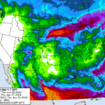
One heat wave down, more to come. It is summer, though, so aside from expecting plenty of hot days, the things to be more concerned about is reference (or potential) evapotranspiration (ET) significantly exceeding precipitation that would ultimately cause drought-related impacts. The National Weather Service provides a 7-day forecasted reference ET product as well as…Read more about More heat on the way[Read More]
Welcome to the start of Hurricane Season that runs from June through November each year. Why would Indiana care about hurricane season? Certainly, by the time any hurricane might impact the state, it will have been greatly downgraded to what is called an extratropical (i.e., poleward of the Tropic of Cancer (23.5° north latitude)) storm…Read more about It’s a Hazy Shade of … June[Read More]
The last few weeks have been on the drier side, particularly for northwestern and west-central Indiana (Figure 1). While temperatures have been seasonal, they are still gradually increasing as we approach summer. Therefore, evapotranspiration rates are starting to increase. This has resulted in the U.S. Drought Monitor classifying much of northern Indiana as Abnormally Dry…Read more about A Bit of Rain Coming Our Way[Read More]
Indiana has already experienced several tornadoes this year with more certainly to come. Of course, this is not unusual since Indiana is often considered on the far northeastern edge of “Tornado Alley”. Tornadoes get their energy from the battle between the cooler, drier Canadian air moving southeastward and the warmer, more humid air coming north…Read more about Tracking tornadoes over time[Read More]
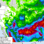
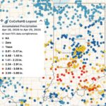
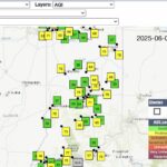
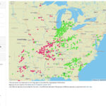
Since the start of July, most of Indiana has received at least 2 inches with up to 8 inches of precipitation (Figure 1). Except for southeastern and east-central Indiana, this precipitation has been well above normal (Figure 2). As a result, most locations have seen an improvement in the U.S. Drought Monitor (Figure 3). There…Read more about Recent rain improves drought across Indiana[Read More]
As I write this article, in a cool, air-conditioned office, I hear others talking about how hot it is outside. I see weather app icons showing bold suns that stress how sunny and hot conditions are and will continue to be. I read Special Weather Statements, issued by the National Weather Service, about an extended…Read more about Hot and dry conditions ahead[Read More]