There is no shortage of weather to discuss this week! Heavy damage to buildings, trees, and powerlines was reported in northern Indiana as a result of the Derecho that occurred on June 13. Unfortunately, there was a fatality associated with the storm. Fort Wayne International Airport recorded a 98-mph wind gust, which broke their record…Read more about Storms, High Heat, Variable Precipitation, and Dryness[Read More]
Austin Pearson

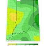
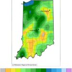
Rain continues to be spotty across Indiana with some areas getting the lion’s share while others are barely seeing a drop. When considering a recent 7-day period (June 1-7, 2022; Figure 1), central Indiana seemed to have missed out on most of the rain. This translated to central Indiana receiving around 5%-25% of what it…Read more about Indiana getting variable precipitation, Indiana State Climate Office[Read More]
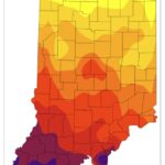
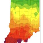
A break from the heat has commenced as average temperatures dropped to 2-6◦F below normal this week. From May 8-14, average temperatures ran from 5◦F above normal in the southeast to 13◦F above normal in the northwest. Across the entire Midwest, there were 858 maximum and 659 minimum high temperature records broken or tied (Figure…Read more about Temperature Swings and Variable Precipitation Continues… Hot, Dry Conditions Forecasted to Return[Read More]
Last week was marked by cooler temperatures and lots of rain. Field days were limited and flowers were waiting to be planted. Then came this week. Temperatures are reaching the upper 80s to low 90s with dew point temperatures over 70F (anything over 60F or 65F starts to really feel muggy). The statewide rain spigot…Read more about From sweaters to shorts – Indiana spring keeps us guessing[Read More]
Lots of wet days, not a lot of rain It seems to be a big challenge these days to find two or more consecutive days without precipitation. What is interesting is the precipitation isn’t always coming in great amounts, but enough to impact any outdoor plans. For example, will it be dry enough for enough…Read more about Climate & Weather[Read More]

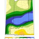
Across much of Indiana, March has provided above-normal precipitation (combined rain and melted snow) except for along the Ohio River where precipitation totals were only 25%-50% of what normally fell during March from 1991-2020. Storm systems continued to bring precipitation to the state through the very end of March, likely improving conditions slightly in this…Read more about Wet conditions expected to continue across Indiana[Read More]
A lack of abundant precipitation over the past month has caused abnormally dry conditions to expand across Indiana this week with several counties in central Indiana intensifying to the Moderate Drought stage of the US Drought Monitor (Figure 1). Some intense weather systems passed through the state this week (Figure 2), however, this was not…Read more about Drought intensifying across central Indiana[Read More]
Well, it was a nice 4 weeks with no drought or abnormally dry designated areas across the state. Unfortunately, the lack of rain over the past few weeks have led to browning lawns, cracked soils, and other tell-tale signs that drought may be returning. The US Drought Monitor has designated three areas in Indiana as…Read more about Dry Conditions Have Returned to Indiana[Read More]
It is amazing to think that some part of Indiana has been in at least the Abnormally Dry category of drought on the US Drought Monitor for over a year. While it has not always been the same parts of the state, certainly northern Indiana has been the most consistently dry. Recently, however, the state…Read more about First time Indiana is drought free since early June 2020[Read More]
As we welcome July, Indiana seems to be in a very wet phase. Or, at least part of the state has been. The jet stream – a narrow band of fast-flowing air near the altitudes where commercial jets fly – naturally meanders in a north-south-north ribbon around the hemispheres. Typically, these “ribbons” also shift eastward…Read more about Storm tracks favor some parts of Indiana skipping others[Read More]