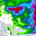
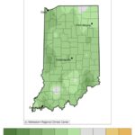
Below-normal temperatures continued through the first 21 days of June as the state average temperature was 68.3°F, which was 1.8°F below the 1991-2020 climatological normal. Temperature departures were 1-5°F below normal across the state, with larger departures in eastern and southern Indiana (Figure 1, Left). Maximum temperatures were near normal for the entire state, and[Read More…]
Austin Pearson

The weather has been absolutely beautiful over the past few days. Temperatures have finally rebounded, vegetation is green again, and agricultural crops are beginning to emerge from the freshly planted fields. Despite the warming temperatures, we still have not dug ourselves out of the below-normal start to May. Through the first ten days of the[Read More…]
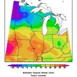
Despite the cooler weather we’ve experienced the last couple of weeks, temperatures from April 1st through 26th averaged 2.3°F above normal for the entire state (Figure 1). Departures have steadily declined as the weather pattern shifted to cold and dry as a result of an upper atmosphere blocking pattern. Since April 21st, temperatures averaged 9-12°F[Read More…]
Much like March, April has gotten off to a warm start. Through the first eleven days, the state average temperature was 5.1◦F above the 1991-2020 climatological normal (Figure 1). High temperatures ranged from 60-70◦F, which was anywhere from 3-7◦F above normal. Low temperatures were not as anomalous, but slightly above normal for most of the[Read More…]
Meteorological spring started March 1st. Astronomical spring started March 20th. Baseball fans might consider the first day of spring to be Opening Day (March 29th this year). Regardless of when one defines the start of spring, so far it has been mostly on the cooler and wetter side. I have yet to meet anyone over[Read More…]
July temperatures averaged 1◦F above normal but had a couple of periods of extreme heat. Twelve stations recorded maximum temperatures in excess of 100◦F. Portions of the month were cooler than normal, which gave way to warmer temperatures again in the last week of July. The heat and humidity continued during the first week of[Read More…]
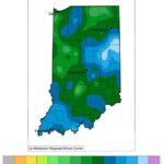
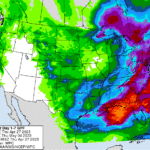
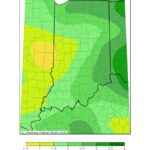
This past weekend brought some much-needed rain to the Hoosier state. Figure 1 shows the total amount that fell from July 13-19, 2022 while Figure 2 puts these amounts into climatological perspective. At least one-half inches fell with some locations reporting well over 4 inches! Was this enough to remove abnormally dry or drought conditions[Read More…]
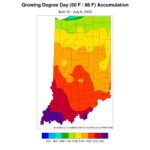
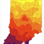
The latest release of the U.S. Drought Monitor has expanded and intensified drought status across Indiana (Figure 1). This map reflects conditions through early this past Tuesday (July 5th) morning, as heavy rainfall was tracking across the northeastern counties. Probabilities of rainfall continue across the state over the next several days, but the challenge is[Read More…]
There is no shortage of weather to discuss this week! Heavy damage to buildings, trees, and powerlines was reported in northern Indiana as a result of the Derecho that occurred on June 13. Unfortunately, there was a fatality associated with the storm. Fort Wayne International Airport recorded a 98-mph wind gust, which broke their record[Read More…]
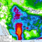
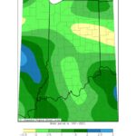
Rain continues to be spotty across Indiana with some areas getting the lion’s share while others are barely seeing a drop. When considering a recent 7-day period (June 1-7, 2022; Figure 1), central Indiana seemed to have missed out on most of the rain. This translated to central Indiana receiving around 5%-25% of what it[Read More…]