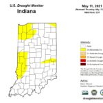
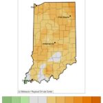
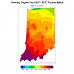
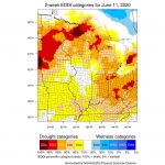
Growing degree-day accumulations still lag while dry conditions linger Beth Hall Indiana State Climate Office Abnormally dry conditions are still lingering in parts of Indiana (Figure 1) with interest growing on how much the warmer weather might exacerbate the situation. Fortunately, the climate outlooks for the next several weeks and through June are favoring above-normal[Read More…]
Austin Pearson

Does snow in April mean global warming is not happening? This week, much of Indiana got to see some snow falling as we were hoping that winter weather was behind us. It is not unusual for some to ask when this sort of event happens how “global warming” could be real when things are feeling[Read More…]
April Showers or Lingering Drought? Beth Hall, Indiana State Climatologist March wrapped up as one of Indiana’s wettest (44th wettest out of 126 years) and warmest (16th warmest). It was marked by unusually warm days and then cool days. Was it ever just average? Certainly, most days fell within the climatological range of temperatures. Precipitation[Read More…]
The old adage says that March comes in like a lion and out like a lamb. The first few days of March started off quite normal and then quickly transitioned to lamb-like (not an official meteorological term) conditions. Then the roller coaster ride began with above-normal temperatures, followed by cooler, stormier conditions, followed by milder[Read More…]
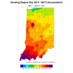
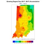
For those keeping track of my articles over the last few weeks, the outlooks of wetter and cooler than normal conditions have been the theme. The cooler temperatures never really came to fruition. In fact, most of Indiana was 1°F to 3°F above normal over the past two weeks (Figure 1)! Regarding the wetter-than-normal precipitation[Read More…]
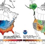
After the last several weeks of predominantly dry conditions, the national climate outlooks are finally showing confidence that temperatures should start shifting to cooler than normal and precipitation will be wetter than normal (see figure). Hurricane Laura will definitely help the precipitation side of that prediction with current tracks having the strongest rainfall amounts in[Read More…]
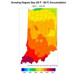
On July 16th, the national Climate Prediction Center released the climate outlooks for August (Figure 1) and the August-September-October (Figure 2) period. Both outlooks are indicating significant probability for above-normal temperatures. Precipitation is likely to be above normal for the southern two-thirds of Indiana in August, but there is little-to-no guidance for the 3-month, August-September-October[Read More…]
The roller coaster ride of Indiana weather continues. Things were drying out across the state with signs of browning lawns, rolling vegetation leaves, and lowering pond and stream levels. Then the rains came. Most of the state received between 2 and 3 inches of precipitation from June 20 through 29th – with wetter areas to[Read More…]
Indiana has been very dry the last several weeks (Figure 1) and conditions are starting to show in lawns and fields. This dryness has been exacerbated by low humidity and warmer temperatures (Figure 2). After a nice respite this past weekend, temperatures will start rising again into the weekend, but may not seem too uncomfortable[Read More…]
June Outlook Calling for Above-Normal Temperatures Beth Hall Indiana State Climate Office The month of May was sprinkled with a record-breaking freeze over Mother’s Day weekend, followed by heavy rainfall the following weekend, with a roller coaster of cool periods and extremely warm periods. We often think of spring as being that transition between winter[Read More…]